 Mini painting I have--possibly view of Lake Almanor from Dr. Dave's cabin.
Labor Day approaches--Banarama "Cruel Summer" fits perfectly as it's cruel that May-September usually rush by while the shitty winter lags. But this year the summer sucked. Was planning to just be depressed for Labor Day when Dr. Dave suggested a trip up to his family cabin. He had tried to put together a Club outing for a couple of years on Memorial Day that would have us do the nearby Greenville Indian Valley Century--but "thing just don't work out as planned." (Paul Sherwin) So Dave suggested that we come up and do the Greenville Indian Valley Century self supported, and then we could do something "fun" like climb Mt. Lassen.
Of the four musketeers, Christine was going down to enemy territory (Los Angles) to root the Giants on, and Ward was set to go until he had to make some last minute changes to his 9/11 blimpe designs. While we have many fun long distance riders in our bike club, it seems that Ward, Dave, Christine and I usually wind up together--while we are aggressive as hell we'll moderate our pace to keep together on a long ride and watch out for each other. And we all were involved in the carnage in Santa Rosa earlier in the year. As Donna real interested in just getting away and relaxing, and she's been off the bike for most of the year--this group would ride at a moderate pace and keep tabs on her; now it would be left for Dr. Dave and me.
Little problem--I have no idea where Lake Almanor/ Mt. Lassen is. While it is an hour South of Mt. Shasta which is almost on Highway 5, it is really off the beaten path--over an hour East of Highway 5. I've only been past Mt. Shasta just 4 times in 30 years (ironically rode it a few months ago), and never close to Mt. Lassen. But, I love seeing places I've never seen before. Tried to picture Dr. Dave's cabin--either small with a pot belly stove and in the woods when I thought of his dad building it, or opulent with super air conditioning (Dave's revenge on me) on a hillside when I heard there is a security gate for the community.
Luckily on the drive up, though leaving separately on different highways from different parts of the East Bay, at one point Dave and Donna/ I were just 10 minutes apart on the road where we stopped for dinner--which thankfully meant we could follow Dave for 2nd half of the unfamiliar part of the 5 hour ride while twilight set in.
Cabin was a mix of what I envisioned--a real log cabin that Dave's dad had built, on a long/ narrow piece of land that ran down to Lake Alamanor, a big man made lake that PGE maintains to generate power. Some enhancements along the way so it was a definite step up from Abe Lincoln's birthplace.
The neighborhood still has many other cabins, but is slowly converting to an area of big second houses. The cabin sits far back on a long narrow piece of land so road noise is almost non existent, and is dominated by a BEAUTIFUL view of the lake through pine and cedar trees. All at 4,500' feet. Unfortunately, as narrow the tranquility of the lake is often broken by loudmouth Gertie Onion, next door neighbor, yelling at her kids "did you take a shower" and their yelling back their shower status from their back deck while Gertie is plumps on the dock..
Cabin is far from basic but inside is a tribute to 1950's decor--dark paneling, dark wood, Solvang type relics....I mention this as going down the long/ narrow/ dark staircase you're in for a good shock when you make the turn into the living room and the lake just jumps in through the picture window. I was in for a good surprise every time I went downstairs.
Town of Chester is nearby--kinda similar to Bishop. Cult bike shop Bodfish Bicycles is in town, lots of places to eat including the Cotton Candy Diner (hamburger topped with swiss and probably cotton candy?), where Dave wouldn't let us eat. We kept running into deer who were not the least bit intimidated by people and would walk around where I'd never expect them.
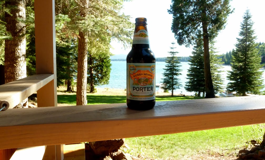 Sept 4 , 2010, first beer if the year after our Indian Valley self supported century. Note to daughter--it's NOT a Bud Lite. Next day had another, so NO drinking below 4,000' this year. Yep, Lake Almanor behind the Porter.
 Dr. Dave and Donna relaxing while looking at the lake.
 (above) Picture of the log cabin (below) Check out the log corners
 Lake Almanor at twilight.
 Forget hack Thomas Kincaid-with light twinkling in the back the scene might have been captured by master painter Frederic Church.
 (above) Outside a nearby strip mall deer are resting from their shopping (below) Only had the bike camera so couldn't open up the lens for twilight, but deer finishing their round of golf.
(Sept 4, 2010) Indian Valley Self Supported Almost Century, 80 miles w/ Dr. Dave, 70 miles with Donna.
About a half hour away is Greenville, where we started the Indian Valley Century. Though cool in the morning, @55, it was very very dry so much more comfortable when it's @55 in the Bay area when the wet fog is rolling in. As an accommodation to Donna, Dave said we should cut out the flat valley ten mile loop the century does twice. I'm sure we missed the GREATEST route ever, (rumored to have a secret buffalo herd) and we need to come back and do this.
The Indian Valley Century would be great for the Diablo Cyclists to paceline around the valley and then motor uphill. It is essentially an out and back. The first 20 miles or so are slight rollers around the north of Indian Valley, passing loads and loads of ranches and fields of Oak, all on a continuous, nicely paved road with little traffic. Then its slightly uphill through the towns of Taylorsville and Genesee (here is where we skipped the 10 mile loop), where Genesee has a great general store/ rest area. Then the climbing stays about 3% for about 15 miles, up to Antelope Lake. At Antelope Lake there is an @7 mile loop, where there are some attention getting rollers but nothing hard-Dr. Dave and I did this in about a half hour as Donna waited for us at the beginning of Antelope Lake. (We established the Dr Recumbent/ Pumpkin Theory of Speed Relativity--if we are going slower than 15 mph, which means we're climbing, I'm faster than Dave, when we are going over 15 he's faster than me--we moderated our advantages to stay together on the Antelope Lake loop but felt good pushing ourselves.)
Except for some small expansion joints across the road--the road from Genesee to Antelope Lake, through the Plumas National Forest, is in good condition with very little traffic--all pickups gave us a wide berth. Climb is supposedly 1,500'. Oaks give way to dense stands of pine trees which give way to large patches of devastation from forest fires.
Donna hadn't ridden over 30 miles for months and was not a happy camper on the return trip--but she hung in there, with Dr. Dave or I setting "targets." Not to many ride photos of Donna as I didn't want to get pushed in the lake. But at a very moderate pace Dr. Dave and I were wondering why we ride "balls out" on most group rides, at this pace we could ride all day--average speed was 14.1 which was about 3 mph slower than if we pushed ourselves..
 Dr. Dave and Donna leave Greenville.
 Many of the ranches/ houses in Indian Valley have unique front yard ornaments.
 Dr. Dave and Donna ride over a scenic water crossing on the way to Taylorsville.
 I'm with Donna outside the general store in historic Taylorsville; though didn't check it out as we were cutting out the 10 mile loop and Genesee, next place to pick up food/ drink, is not far down the road.
 Wooded areas and more interesting front yards on the way to Genesee.
 Dr. Dave and Donna didn't send me the email re 'jersey of the day!' Outside Genesee General Store, a great rest stop.
 View from the patio of the Genesee General Store. Definitely joins Sunol and Volcano as great places to take a break.
 Barn while leaving Genesee.
 The blue bottle yard.
 Dr. Dave on the climb to Antelope Lake--bring on "the Boxboy"
 Pumpkincycle species orange barked pine.
 Unfortunately a forest fire a few years back has a lingering effect of the area right below Lake Antelope.
 I'm in the Plumas National Forest. Have GT bike so I could carry supplies (and have a bike bag nearly as big as Dr. Dave's) but with so many stores en route there was no need. But as I took off vest, t-shirt, arm warmers, knee warmers, and also carried Donna's extra stuff, bike with bag came in handy.
 Donna and I at Antelope Lake. She'd come back here to wait for Dr. Dave and I to loop the lake.
 Continuation of gentle climbing after Antelope Lake.
 At campgrounds above the lake a very very basic general store. Very basic.
 Dr. Dave at high point of Antelope Lake loop. Now time to get Donna waiting at rest area and ITS ALL DOWNHILL back to Genesee. Funny though, many uphill rollers back to Genesee for an expected all downhill.
***
(September 5, 2010) Mt. Lassen Climb, w Dr. Dave, 32 miles, 3,600' feet of climbing.
***
The next day we drove to the base of Mt. Lassen, or more properly known as Lassen Peak. The most Southerly mountain in the Cascades Range. Eruptions over the years (one in the 20th century) destroyed its original peak and lowered Lassen Volcano by 1,000 feet.
***
So Lassen Peak/ Mt. Lassen pales in comparison to its closest neighbor, Mt. Shasta. Lassen is 10,464' above sea level, and rises 5,229' above the base, while Shasta is 14,179' and rises 9,822' above its base. While you can't get close to the top of Shasta on a road bike, you get pretty close on Lassen, riding up to 8,512' above sea level, starting at the parks main entrance at 6,700.' Another difference is that while Mt. Shasta has roads that dead end on the mountain, the Mt. Lassen road is Highway 89 that runs up to the 8,512' point, and then goes down to campgrounds before heading north to Mt. Shasta.
***
Dr. Dave's idea was to ride the 8 miles up to the highest road point, then descend 8 miles to a campground to get water, and then do another 8 mile up and down from the opposite point.
We started early and while it was cool (yesterday was the hot weather ride, today was the cold ride), the dry air made it very comfortable. In fact, half way up I got rid of everything except a sleeveless jersey and knee warmers. Apart from the climbing, passing geothermal hot spots certainly helped create the illusion of warmth--the bubbling Sulphur Works were within the first mile of the climb . Luckily we started early as while going up there were numerous cars, later coming back down it looked like the bus loads of K-Mart shoppers had arrived at Lassen National Park--veering every which way looking for the blue light specials.
***
We only saw one other cyclist on the road; at the road summit. He was from the Town of Mt. Shasta which had me later conjur up a scenario later that we could have ridden out to Mt. Shasta. As it turns out he started in the park and supposedly the route to Mt. Shasta is "all downhill" from Lassen National Park--and not in an elevation sense.
***
The climbing was very gentle--kind of like the South (Easy) side of Diablo. Near where the road topped out we could see the summit trail--covered by human ants making the ? mile long steep trek. We passed lots of meadows and streams collecting what was left from the remaining oatches of slowly melting snow. Dr. Dave warned me to put on clothes before we started the descent to the campground, and he was right--it got cold fast. The road was in good shape, and wide, but was twisty and "ran right to the edge of the cliff."
***
After Dr. Dave checked out bear lockers in the campground for leftover Apple Crisp & ice cream, we started the climb and being on the Northeast side it was not as nearly as warm as it had been earlier. We passed a popular attraction--Bumpass Hell--a 3 mile hike through hydrothermal features. Later, when reading about it I wish we had seen it. We quickly arrived at the high point of the road again, I bundled up (the Ward maxim--"if you got it with you, wear it"), and we started the twisty 8 mile descent--now with tourists clogging the road at a few attraction/ parking areas. I was real surprised as I'm a slow descender--no car was on our butt due to the twisty road that had them scrub speed more than Dave and I did.
***
When we got back to the entrance we met up with Donna who had toured the visitors center and some low level spots, and we drove back to the summit so she could see some of the points of interest we had seen.
 Dr. Dave and I at the visitors center-we are already over 6,000' and we have to get to 8,000'--essentially riding up that "hill" behind us.
 (above) Steam from "The Sulphur Works" and (below) some hot mud bubbling up. Some ass threw a bottle in (far below) Later we'd drive back up so Donna could see this.

 On the ascent--Dr. Dave pretty close to the shoulder--oh, there isn't much of a road shoulder. Arrow marks road we came up far far below.
 Dr. Dave points to Lassen Peak, we'd ride around it 2,000 below.
 Climbing, sunny and dry air--what's not to like. I soon lose 2nd jersey until the descent starts.
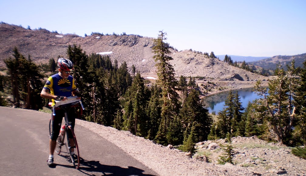 Though there are no intersecting roads to get lost on--as I'm with Dave, and I usually get lost, he's taking no chances and checking a map above Lake Helen.
 High point on the Mt. Lassen road, 8,511'. There is a patch of snow behind the sign.
 Of course we need a photo with snow
 Dr. Dave (above) and me (below) in front of Lassen Peak and a meadow filled with running streams. (far below) closeup of meadow with stream

 Lake Almanor in the distance to the right of the photo; I think the cycling doctor is happy--really.
So not a long ride but when you have 100'+ of altitude gain for every mile you get a nice climbing ride. On the way back we stopped off at Bodfish Bike, and enjoyed the lake view for the rest of the day (well Donna and I did, Dave was doing lots of minor repair.) At night a long bs session that used to happen too often in college and not enough since--but this one grounded in a lot more reality than the one's 30 years ago.
******
Weekend shot by too quickly. We left early the next morning to try to beat holdiay traffic--it was 55 degrees at Lake Almanor (elevation 4,000+). An hour later, close to Highway 5, Donna asked me why I had the heat on in the car--I pointed out we were now below 1000' and the temperature was "suddenly" 85 degrees. All summer cabins/ vacation homes need to be built above 3,000'
No comments:
Post a Comment