Wednesday, May 28, 2014

Sierra Century Training-Norris-Redwood-Mt Diablo While Knackered Metric + & Sutter Creek-Volcano-Rams Horn-Share Ridge Recovery Ride

****************1 week to the Great Sierra Century Double Metric****************
***************1 week to the Great Sierra Century Double Metric*****************

Memorial Day Weekend
May 24, Norris & Redwood Road w/ Mt Diablo Bonus--Diablo Cyclist ride with Dr Dave and Ward on the bonus miles  80 miles, 6,720' climbing


May 25, Sutter Creek-Volcano-Rams Horn-Shake Ridge Recovery ride-solo, 47 miles, 3,870', (80% of climbing on first half of ride)

I was excited.  Weather promised to actually be 'don't need to take a vest or arm warmers HOT' and our club was going to do an always popular,  relatively flat ride in Solano towards Lake Berryessa--and I need to get some speed work in.    That is we were going to do it until Ward figured out that crazy Memorial weekend drivers towing boats towards Lake Berryessa and bikes may not be the greatest mix.   All of a sudden everyone on the email tree opted for the local Club ride.  I think this is the first out of town ride the bonus mile group ever blew off in unison.

The local Club ride was nothing special, a metric loop with the Norris Canyon climb (1.8 miles, 4% with a 7% kick near the top), the ugly Crow Canyon Road leading into the Redwood Road climb (2 miles, consistent 5%.)  Only item of note was that a club member who never pulls latches onto Dr. Dave's and my wheel at the start of the Norris climb.  I wanted to open it up but didn't want Dave to think I was attacking.  Soon Dave sensed the passenger so he picked it up gradually, we traded blocking the wind on the climb, and dropped our passenger.   Dr. Dave is really riding strong---resulting from hard training for the Sierra Century in case he has to drop  Gustavo (his unwanted buddy from two years ago.)
Dr Dave flying by on his way to Redwood Road and chasing down someone

Going into Redwood Road some guy whizzed by on a hill leading into Redwood Rd (1/2 mile, 6%) and I tried staying with him but failed miserably--hill too long and too gradual for my liking.    Dave jumped out of the group and eventually caught up to the guy.   I pulled over to take photos of our group and then rode hard to get back near the front--I was leading Christine up Redwood when she yelled the warning "Postal."  Oh crap--a 120 lb young guy with no saddle bag, I already got clocked moments before.  But about 5 second back his normal sized friend came along and I jumped on his wheel and rode hard with him back to his friend until we crested the top.  Then it was Dave, Ward, Christine and I back down for our acktavulgers--a new lady was amazed that we come back down hills to ride up with the slowest rider.  Why not--Bonus miles.

Our group then went to shit during the hard ride down Redwood (sudden uphills and headwind.)  Brian flatted so when we waited at the regroup point for 10 minutes and with a quarter of our group missing some of us rode back up Redwood and some split to go home.  Brian had double flatted.  Later he and Don skipped the Moraga Park while Ward, Dave, Jack and I pulled in to get liquored up--it was definitely getting warm.

Next week on the Sierra Century the big climb of the day, Slug Gulch, comes at @mile 70 during the heat of the day. What better way to get ready for it than to go up Mt. Diablo after 50 miles during the heat of the day--even though Slug Gulch will be shorter--steeper and hotter (very dry in the Gold Country.)   Ward and Dave hate hot weather but they were game and we started up at what was supposed to be a friendly pace.   Until the first guy (unbeknownst to us doing intervals)  roared past.
Dave and I at the Ranger Station (WI)

Dave and Ward channeling the happy riders on the Tour of California (Dave insert)

The three troublemakers at the Junction.

 Now in the past I was the competitive maniac and we depended on Dr. Dave to calm the waters, but now he just throws gasoline on the fire--so we both start chasing the guy doing intervals.  This was good as I could no longer hear Ward laugh at my lousy pedal stroke.  We briefly caught back to the guy between his interval set until he took off again but Dave and I rode hard chasing which meant we paid little attention that we were dead tired.   Dave was much more consistent, and above the ranches he pulled away from me.   When I got to the Junction I yelled we should go back down for an unhappy Ward, who was doing his first bonus miles since injury.  So double bonus climbing miles for Dave and I.

Dave in the remodeled lower parking lot.

Dave and I at the top of Mt Diablo--the Pittsburg-Antioch-Brentwood megaplex behind us.
After a rest at the Junction--where we chatted with the interval racer and a guy we had passed ironically wearing an old Sierra Century jersey, Dave and I took off to the top.  This time we were really dead and didn't do much to keep up with another guy who passed us--though we rode hard enough to stay 500' behind at all times.   Downhill was great in jersey only.

My original plan was to do a hard ride on the Sierra Century course after such an ez/ flat Saturday ride.   A great ride is the 24 mile climb from Sutter Creek (elevation 1200') to Hwy 88 elevation 4,000') where the pine forest gets thicker and thicker the higher you go. I was going to start in Ione which would add about two dozen miles of serious rollers to each end of the ride, but after getting knackered on Satuarday I talked myself out of the "bonus rollers" and started in Sutter Creek.

The first 12 miles is along the fairly shaded Volcano Road (12 miles, 1%, though picks up with some 6% rollers for the last mile or so.)  The first and last few miles of pavement is good but the middle section has terrible and uneven patch jobs (it would still be the BEST road surface in Sonoma County.)  At the end of the road is the tiny town of Volcano. I've been in Volcano dozens of times but never checked out the ancient cemeteries until today after a tip off from Dave.
Sutter Creek

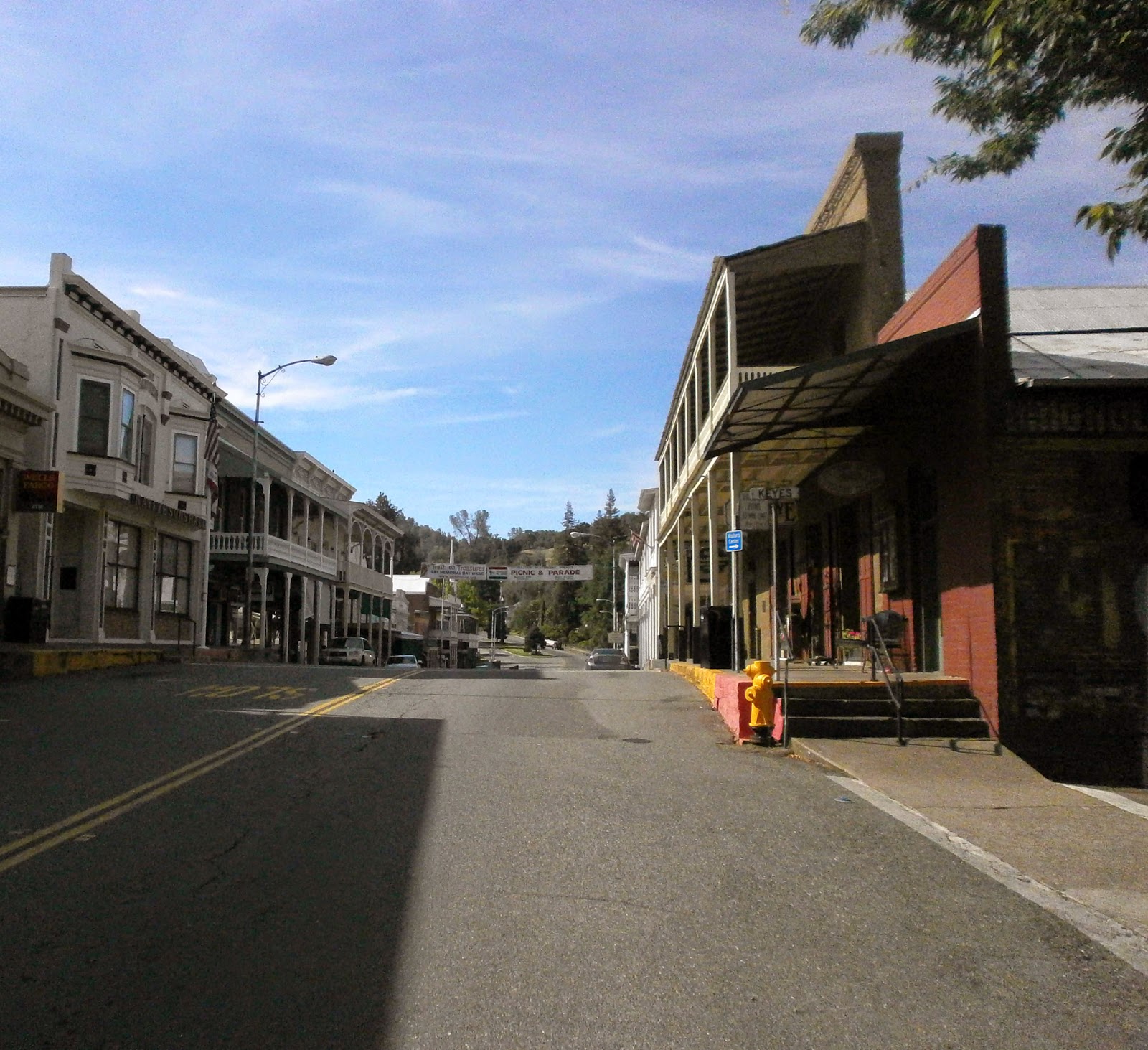
While the Sierra Century is the greatest organized ride--I tell folks not to expect any "oh wow" views.  But when I did the Metric for the first time, circa 2000, I was amazed when we made the right turn and saw the quintessential western town, Sutter Creek, for the first time.   Early morning, not covered with cars yet, kind of like this photo.


I'm in Sutter Creek

After Volcano is a signature Sierra Century climb, Rams Horn Grade (2 1/2miles, 6%) which is actually longer as it leads into  a bunch of 6% rollers for another few miles.   Eventually the 6% rollers give way to 9-10% rollers.  In any event the ride to Hwy 88 is slow--and not a consistent grade--which I like.   Shake Ridge Road is lightly populated, beautifully forested, nicely paved and had very light traffic--along with NO traffic stops.
At 3,000' its cooler than Sutter Creek and smells great from teh densly packed trees..
Volcano is also a Kodak Moment on the Sierra Century. Though the "Greek Theatre" has all the integrity of a Hollywood Set, it still is always impressive to look at.   Unfortunately, a rest stop is no longer in Volcano Park.


As a recovery ride I was trying to keep my power down and spin alot--until some guy comes by without saying a word.   Jesus--we'll see a half dozen cyclists today--everyone calling out greetings/ warnings they are passing except for this unfriendly douche.  So I get my dander up and go over what I wanted to do until I drop the guy on the next sharp roller.
Look back down Rams Horn shaded climb.

Shake Ridge climb to Highway 88--on the Sierra Century we'll go down the Fiddletown expressway twice--coming in from both ends of Shake Ridge Road

Film short of riding along Shake Ride Road --which is constantly lined by tall trees.

There is one general store on Shake Ridge that looks like a museum/ junk yard and I get another bottle of water now so I can picnic when I reach Hwy 88 and don't have to stop on the fast return trip.

A few steeper rollers near the end (last mile averages 5%)  and a few cars actually pass as close to Hwy 88.   There were actually two people hiking up Shake Ridge Road--I'd see them 20 minutes later when I was picnicking.

Though not scorching hot it is dry.  You can feel the moisture being sucked out of you. When I got to the point where Shake Ridge Road meets Highway 88 I walked down an embankment into the pine forest and ate my peanut butter/ pumpkin butter sandwich in the shade.

Picnic at the end of Shake Ridge Road/ @Hwy 88

Daffodil Hill covered with squawking peacocks
Return trip was uneventful.   Instead of a pure out and back instead of going into Volcano I deviate near the top of Rams Horn and take Shake Ride almost all the way back to Sutter Creek.  There is more traffic.  I was probably passed by 12 cars all day--about half on Shake Ridge as I approached Sutter Creek.    The Shake Ridge road surface is much better than Sutter Creek-Volcano Road's midsection, much better for the usual high speed downhill punctuated by sharp uphill rollers.

Sutter Creek in both directions early in the day--later lots of people will be in the water in the bottom photo., 

Back in Sutter Creek I saw what its like when its hot--many families were playing in the creek.  I picnicked on another peanut/ pumpkin butter sandwich at the creeks edge.

May 26, Mt Sutro Walk, 7 miles.

In 2003 before my first double metric Sierra Century, I took the week off and rode every day needing "more prep--more prep" until the witch ordered me off the bike on Thursday. Now, after two days of climbing rides on warm (hmmm, maybe hot) weather--I figured I'd change up and take a hike around San Francisco where it will be 20 degrees cooler.
SMART cars look so stupid on the highway, but parked in a tight space between SF Driveways they finally look good.

The Painted Ladies--tour buses and paint company vans prohibited.

The easy to miss entrance to the Mt Sutro Forest

Rare view from the forest.

On a typical trail.

Not much to see at the top--if there was a souvenir shop I'd get this sign for Ward.

Walking back through the Haight

Destination was the Mt Sutro forest, but instead of taking mass transit over I walked over from downtown, outward via the picturesque Alamo Square area with the "7 Painted Ladies."  Back I went through the interesting Haight Ashbury.


Nothing much happening in the Mt Sutro forest except birds chirping and eucalyptus swaying--real relaxing.

The real surprise was the Mt Sutro forest.  Though a holiday there were not that many fellow hikers and no deadbeats.  For much of the hike you have no clue you are in a city, save the small part you are right behind UC Hospital's air conditioning plant, and the few times you can make out the Golden Gate Bridge through the giant eucalyptus.

If the idea was to rest my legs I sorely screwed up--my "well developed cycling legs" always get a bad case of shin splints whenever I do something as intense as taking a long walk.

Monday, May 19, 2014

Patterson Pass From Hell Redux (2014)

***13 days to the GREAT Sierra Century***
    ***13 days to the GREAT Sierra Century***
          ***13 days to the GREAT Sierra Century***

(Sunday May 18, 2014) Patterson Pass From Hell Century, 88-92 miles, @4,000' climbing.  Who the hell knows--Garmin crapped out.

Patterson Pass has an average grade of 5% for 4 1/2 miles, but the higher you get the headwind and grade pick up together.   When I went up today the head/ cross wind was a steady 26-30 mph with gusts of 38-42mph.   This was about the same as President's Day Patterson Pass 2013

One rule before we do an organized century ride is to ride EASY the day before.   Before power meters to keep the bike in the SMALL chainring so wouldn't be temped to chase anyone.   This went down the toilet this weekend.

Usually I ride ez with Mrs. Pumpkin on Sunday--but Mrs. Pumpkin and oldest Miss. Pumpkin off doing a 1/2 marathon this weekend.  So I figured I'd do the Diablo Cyclist club ride both day (oh crap--on Saturday its Peet's Coffee, again) and on the Sunday ride--which is usually short--I'd add on the GREAT Patterson Pass.

Two things threw a monkey wrench into the plans.  Though only 50 miles the Peet's ride goes over a few hills into Oakland for it was a heavily contested ride with 4,700' climbing.   Powerhouse Todd and climbing Matt (who just finish highly on DMD) and I were racing the Bears, though Todd set me up for a nice finish on the last steep-short hill.  Ward was out--this was his ride with most climbing in 1/2 a year.   Christine kept slamming the steep rollers at the end.   So much for taking it easy.


(Top) Todd and Matt on the breakaway on the Bears (2nd) Amy yells sprint point and gets ahead of Jeanne at the end of the Bears (3rd) Christine in Tilden Park waiting for the long downhill into Oakland (Bottom) Todd wants to go back to the Attractions.

At the end of the ride Todd was going to add Mt Diablo.  I had some home repair projects to do so it was either bonus miles today or Patterson Pass tomorrow.  And even though everyone else said the weather was perfect and I was delusional, I thought it a bit cold--not a day to ride down Diablo after such great mid week weather***--so the next day sounded better and better. (On TOC day and the next it was 90+ on Mt Diablo.  Most people and the pro riders were fried but I loved it--going up 3 hours after the TOC was over and the Mountain was a ghost town.  The next day was even warmer where the downhill is worth a million bucks with no need for t-shirt or vest.)

Next day was the Diablo Cyclist breakfast ride--where after a stop at a coffee shoppe we decide where to ride.   Unfortunately the trees were dancing in the parking lot--not a great sign.  On our ride for coffee the wind was hardly noticeable as we all line up behind Mark and Amy and their tandem.   Hmmmm-maybe the wind is dying down.


My being tight from the day before was certainly a bigger problem than any wind.  At breakfast I talked my compatriots to ride to "The Trees"--which is in the Patterson pass direction.


So much for taking it easy--on the first part after breakfast Cyclocross champ Mark and Amy hammered up the hill and dropped the group while I stayed in their draft.  Things got a little more civil when they turned off, though Ward pushed the pace to the County line.   It was now mile 25 and a few people kept saying "are you really going to Patterson Pass?"  every time we were hit by a wind gust.

But as you may recall from prior posts the Patterson Pass loop is almost magical.  No traffic signals, virtually no traffic, smooth roads, through desolate land dotted by windmills.   Always a tailwind to the run in to the Altamont Speedway-though you hope not a HUGE tailwind as you have to go back into it on the Patterson Pass climb.

In short the windmills were fiercely turning, I was dead tired when I started the Patterson Pass climb, and things did not get better for the rest of the day.  The wind was as fierce as two years back when our group was pelted on the Climb.  Also can be seen as a high quality u-tube video--here is a smaller version of today's ride.

Some highlights (or lowlights)
There was GREAT food on my Century ride

-Stopped at 7-11 on Vasco to liquor up and so I wouldn't have to ride down into Tracy.  When I left my power meter wouldn't register.   This is the exact spot my power meter shut down when I was coming back from Patterson Pass two months ago???
-Run in to Altamont starts past the Livermore dirt bike park.  Usually when we go by there loads of activity.  Quiet today as serious accident-rider laying down on track with ambulance on the scene.
-Toting peanut and pumpkin butter sandwich and planned to eat at the Altamont Speedway--but too windy.
-On half the climb up couldn't use the handheld to take video as needed two hands on the bars.
-Near the top had both my hands on the bars and a sudden gust of wind moved me 3-4' to the left--luckily no cars coming down.   Two cars coming down a little later on the steepest grade and I virtually stopped until they went by.
-At the top flew my metal bike with one hand as Cisco and Blinky had done with their carbon bikes two years ago.  To get video I basically hid next to a parked van.
-Frazzled-got lost in Livermore and took wrong turn which got me to busy airport stretch on Isabella/ Conconnon instead of the quieter N Murrieta for leaving town.
-The rest of the day there was a constant cross/ headwind until the downhill past Blackhawk where miraculous I caught 3-4 green lights in a row.
-At end of ride--after saving ride on Garmin, Garmin froze up.  When I turned it off and back on it said there were no saved rides.  Oh well, didn't need to see that I went 8mph.

Sunday, May 11, 2014

MothersofInventionLode (Motherlode) Century (2014)

***** 21 days to the Sierra Century ****

May 10, 2014, Motherlode Century, 100 miles with bonus add on of ALL of Highway 153, 10,000'+** climbing, w Dr. Nunzio

**
per my Strava 10,820'
per Nunzio's Strava 10,305'
per my Garmin 9,453'


Vicki Ashworth for El Dorado County Superior Court Judge--unless she's a Tea Party member
Dr. Nunzio has been pimping this ride for two years, with great views and great steep climbs in the middle of the Gold Country.  While I'm real versed in the lower Gold Country (Sutter Creek-Plymouth) and have done some riding in the upper Gold Country (Auburn)--I have never ridden in the Placerville-Coloma region.


Funny thing is I used to really scout out and study new rides that I was doing, but I just signed up and didn’t do much scouting (except reading some blogs that told about white knuckled twisty descents.) Nunzio told me of the great time he has staying at the campground on the American River next to where the ride begins, and in a fit of insanity I said I’d camp out also--and then regretted committing to it.  I hadn’t camped out in 15 years. My old bike club camped out a lot--the President for life would tell everyone how great camping and biking was as he retired post ride to his rolling taj-mahal while the tent campers took a cold shower from under the enema bag hanging from the tree or jumped into the cold lake.

The Earthtrek Expeditons campground already had tents on platforms but Nunzio warned their foam pads were a bid worn--so it was time to find and clean off the thermorest pad & mummy sleeping bag that I wouldn't get into cause of my claustrophobia. Coffee and breakfast???--Nunzio thought there may be electric outlets but unsure if by all tents, so it was packing a plug in coffee pot and the Colman stove and stinky gas canisters. My camping tube florescent lanterns were all dead--5 years obsolete anyway, so just packed my work lights that can work off a charge.. The weeks leading up to this ride was studying all the crap I need to take camping (40 degrees at night--what change of HEAVY nighttime clothes to bring), and never looking at the bike route, etc.

Nunzio and I couldn’t go up together the day before, when I always try to get in an ez spin the day before an event. I could have gone straight up to the area where this event was being run but figured why not take the GREATEST pre ride route which is part of the Sierra Century course--the Sutter Creek-Volcano out and back. Mild climbing (2-3%) for 9 of the 12 miles along a shaded road next to a running creek bed to Volcano, then a few steeper (4-8% ) sections in the last 3 miles until hitting the tiny town of Volcano. Almost no traffic and though the road is now a bit rough it is not in disrepair.


Along Sutter Creek-Volcano Road

Arriving in Volcano and the St George Hotel

Waffle in the Park

I'm on the Volcano Cobblestones
In past years the rule on pre event rides was to keep in a small chain ring but with a power meter I was going to keep under 175w. When you ride slowly by yourself you think a lot and that’s what I did towards Volcano. Its almost 10 years since my dad died and was thinking a lot about him. At the start of the ride I wanted to be in Volcano--right now--so I could quickly GET BACK---and start driving to Coloma. I get this ADD thing from my mom, if I’m on Avenue A I have to go to Avenue B thinking they have the greatest thing ever there. All of a sudden I could hear my dad, always laid back, never in a rush, saying “you know, Rome wasn’t built in a day.” Hell, enjoy the moment, and for the rest of the day I enjoyed riding slowly to and back from Volcano taking in the running creek and birds and butterflies buzzing about. In Volcano, instead of eating in front of the general store, as we always do, I went into Volcano Park that used to be a Sierra Century rest stop. There I slowly enjoyed a Liege Waffle lunch.

Elevation and Route Map--Route Started going clockwise with two bonus loops at southeast and southwest portions of the map.
Highway 49 (no not 49’ers) runs through the middle of the Gold Country, and before the internet and EBay a relaxing days was driving along and stopping at the dozens of collectible stores that dot the route looking for ANY Polo Grounds souvenir.  Hadn’t driven the section from Plymouth to Placerville in 3 decades, and I had never gone North of Placerville on Highway 49. When I got near the campground I saw a sign for the town its supposedly in  and made a quick left turn and was suddenly lost so I had to pull the Garmin from the trunk. It took me on this ½ lane semi paved hilly road eventually looping back to the main drag--I passed what I had passed a half hour ago, and learned I had turned 1 block from where I was supposed to go. A bit frazzled I was lucky that Nunzio was in the confusing parking lot shared by a half dozen businesses all down their own side street to show me where to park.
I'm wearing the official MothersLodeofInvention Ride t-shirt

I'm read for a pot of coffee

Picturesque campsite at dawn


The  campground was real nice--canvas tents on platforms. As getting individual tents I thought Nunzio booked the smaller tens along the river but he had us each in huge cabin tents about 150‘ away from the water.   What drought?--the South Fork of the American River was fiercely running and the booming sound of rushing water was great, which intensified at night. Yes there was an electric outlet--at ONE tent three tents away. Only real complaints were that the parking lot was 400’ from the tent so it took 7-8 long trips to unload. Bathroom facilities were indoors with showers but very small (and dim) for such a large place.

Low key check'in across the street at a table set up by Friends of the El Dorado Trail. They gave out a route sheet that was real confusing--instead of having a route sheet for each course, they gave out an all in one route sheet (with NO map) that had the basic metric course and then the add on loop options for a full century.  To follow this you’d have to 0 out the mileage on your cyclocomputer beginning at the two extended loops. I was just hoping the course was well marked--and it was except that sometimes we followed orange arrows and sometimes we had to follow yellow arrows.
One of these is a REAL deli sandwich.  One of these is a phony deli sandwich with lots of sprout thingies

Redneck looks into a store of interest


Nunzio was down on all the local choices to eat and he suggested driving back to Placerville--there was a nice organic restaurant in an old stone creamery building that Mrs. Nunzio really liked. Red flag as Mrs. Nunzio is a vegetarian but I was told they did have some meat dishes. How can anyone ruin pasta so I was up for it. MISTAKE. The menu had NO pasta and had only 1 NON veggie or tuna filled dish--a turkey sandwich. OK, not my favorite but safe before the ride--how can you ruin a turkey sandwich?? BY PUTTING 23 DIFFERENT VEGGIES ON THE SANDWICH AND BURYING THE ONE SLICE OF TURKEY AMONG THE FIELD OF WHEATGRASS.

Back at campground I fired up the stove for some coffee--coffee does taste best when camping, and after bs'ing a little Nunzio and I turned in. He and Ward did fill me in on a trick--to take an extra old water bottle you no longer use so in the middle of the night…… In any event it was warm when I closed the tent flaps, didn’t need all the sleeping clothes I had taken, used the sleeping bag as a blanket, found out the batteries were dead in my Walkman (so no Giants game), read for a little and was asleep in the dark at 9:30.

Listening to the running water was great.  Wow, this camping is.....shit... I’M FREEZING. Its 3:30 and icicles are growing in my tent. OK--not quite but temperature had gone from 65 to 45 degrees. Thank Buddha for the old extra water bottle. Decided to use my sleeping bag as a mummy bag. Was up for awhile, or so I thought, but the alarm at 5:30 did wake me up. I was surprised when I opened up the tent flap and saw it was already light and there was lots of activity going on.

We planned to start the ride at 7:00 so in the next 1 ½ hours it was stretch, make oatmeal and coffee, start the 7-8 trips bringing crap back to the car (next year will take less and stay 1 more day), shave in the too dark bathroom, wait for an empty throne and out on my cycling kit which was very very cold.   

(Warning: Miles below are from memory--I tossed the useless route sheet)

(Miles 1-10)
Dave and I started at 7:10--and most other cyclist were already on the road. The first 10 miles are along Highway 49 on long but gentle climbs. Dave and I saw less than a handful of cyclists, many more cars that were speeding past next to us. Fingers were frozen--it was definitely cold. At that point I figured this was going to be a real crappy ride if we just rode along the Highway.


Nunzio on Highway 49, early morning
(Miles 11-30)
We suddenly turned on a back road toward picturesque town names like Pilot Hill and Cool. Not a lot of traffic on this road, which meant the road surface became a bit rough. A rest stop at around mile 15--usually we’d skip it but Dave and I were already hydrating well for the climbing ahead so we figured good to top off our bottles. Friendly rest stop workers at each AID stand, with lots of basic food and good fresh bananas. Up to about mile 30 was nice rollers along a forested back road.


Pilot Hill rest stop and antique show

Dual selfie
(Miles 30-50)
Rock Creek Climb   3 1/2 mile, very steady 6%
Mosquito Road Descent 2 miles, -8%
Mosquito Road Climb 3 1/2 miles, 6% with the first 1/2 mile at 15%, the first 2 miles 8%

From mile 30-50 the route would basically be big climb of the day along a Nunzio friendly climb--nice steady grade. A long death defying twisty steep grade downhill to a scenic water crossing. Then a Johan friendly climb with sections of double digit grade back up.
When we pulled into an AID station before the first climb I saw the Alta Alpina Bike Club, decked out in beautiful new ORANGE kits. Now, I am not impressed with their Alta Alpina Events jersey or 8 pass finishers jersey--I have to see if I can buy their Club kit at this years event. On the first climb a blond wearing the new Alta Alpina jersey was climbing well and setting a steady pace, so I just settled in to her pace while Nunzio kept the pace down as he can easily spin away from me on the steady climbs. We did put some digs in at each other near the top.
Alta Alpina Event Jersey's not the best.  Here an Alta Alpina club member has on a great club kit I gotta get.

Another AID station before the “fun”--the twisty, knarly, steep descent, the first part was terrible as the narrow road was a bit rough and heavily shadowed--the second part was just as steep but smoother and in full sunlight with a view. I pulled off on one cutout to take a photo and then continued on surprised how the descent had gotten better. Funny as just a sheer dropout off the road for most of the descent--and one 100’ had a concrete guard rail wall.
Looking down from Mosquito Road.

Another AID station where I debated whether t-shirt, arm warmers and knee warmers should come off as alternately hot and cold.  A brief climb and then another more twisty and narrower descent. I was enjoying it until an unmarked hairpin suddenly appeared that I wasn’t ready for--luckily no cars were coming up as I swung wide. And even though not lots of traffic there was some, as the line of cars waiting to go over the one lane bridge at the bottom would attest to.

Coconut jersey for CA Mike 

Dave and I enjoying the sunshine--the cold wuzz just pulled off the arm and knee warmers
Few cyclists at the bottom cuing up to cross the bridge once the traffic backlog settled down, some taking photos. What waited for us on the other side was the 13-15% grade to get us out of this place. It was really too long a climb for my liking, with the long 13-15% grade settling into a relief section of 7%, and then a few more double digit kicks. It was the Sierra Road of the Gold Country.

Scenic Water Crossing Bridge where 15% climb awaits 
15% hairpin Nunzio is about to navigate--"Hit Me"
To kill time on long rides, we yell out “scenic water crossing” on all bridges, no matter how small and even if there is no water. (Long story how this came about)  On this ride a few real scenic water crossings but not many. So I came up with a new game. Tons of billboards for the El Dorado Judicial Candidates. One billboard had the picture of the candidate-a young cute woman. So every time passed her billboard had to cheer and yell out support, every time passed an opponents billboard would yell out “he’s a bum.” Hopefully the judicial candidate I support isn’t a Tea Party member.

(Mile 50-69)
Mile 50 had an AID station right outside Placerville (who knew we were so close) and the start of the optional 20 mile Apple Hill loop. This stop had premade Subway sandwiches.  I didn’t want to chance tasting week old lettuce so I passed, though Nunzio said they were quite fresh unlike those found on a Planet Ultra ride. A lady who saw me shaking my hand offered me some arthritis cream---don’t know if it helped as no more killer down hills but I could start grabing my front water bottle again. Her male companion had a huge MR BILL-Noooooooo! Doll on the back of his bike--nice change from a few of the OH SO SERIOUS cyclists we see on the road who can’t say anything when passing fast (most start to stall out 200’ later--I got back to one but my heart was racing and I backed off--oh to be 10 years younger.)  
"OH NO" Mr Bill confused by the course route sheet and markings

Dr. Nunzio on the bike path that starts the Apple Hill Loop.


Scenes from the Apple Hill Loop
Apple Hill loop begins on a steep bike trail. When we hit the main road we saw a few cyclists coming back so I thought it was a short out and back. No, turns out it’s a self supported picturesque shaded loop among apple orchards and xmas tree farms, with the first half real slow as continual uphill rollers. Luckily I grabbed an extra power bar at the last rest stop. The first half seemed to be the dog miles that drag on and on---then the second part was a very quick return to the right outside Placerville AID station.   I was cold on the return--earlier I had been happy pulling off my knee/ arm warmers, now I wished I stopped to put my vest back on. Mile 69, AID station, where we saw lots of cyclists just beginning the loop and lots of cyclists in the AID station puzzled when trying to understand the route sheet.

(Mile 69-74)
Right down the hill at mile 70 was downtown Placerville. Holy crap, the wheatgrass sandwich restaurant we ate at last night was right in front of us. Going through now crowded Placerville was cautious but nice and then we started back up Highway 49 for the next 4-5 miles and this was a clusterfuck.
Noooo-don't make me eat lunch at the Cozmic Cafe.

 Going up means grades of 4+% along a Highway with no shoulder and now lots of traffic. At one point a line of angry pickup trucks were stacked behind two cyclists 200' in front of us on a narrow section--Nunzio and I had to travel slower than the bikes in front of the pickups so we didn’t roll into them during a frequent sudden stop. Lots of pickup truck horns blasting until the road widened and the cyclists could pull over and let the angry motorists pass. I was happy when we turned off Highway 49 at mile 75 to start another confusing bonus loop.


(Mile 75-97)
We were on a ridgeline and the wind picked up where we’d get a strong headwind that suddenly morphed into a crosswind and even a tailwind. We were joined for most of the rest of the ride by a strong couple from the lower Gold Country who were puzzled by the esoteric route sheet and were glad that Nunzio knew this course. Some nice semi long--noticeable but not steep rollers. “HE’S A BUM”--Judicial candidate signs. All of a sudden, a turn marked for a “Dead End road” Volunteer at the turn assures us its not a dead end.

That was debatable. The road ended at a creek with a nice current. I was going to ride though and picked a shallow line when a volunteer told me that the path I picked was wrong as the pebbles gleaming were loose and the bike would slip out. With that I lost my nerve like most folks down there except Nunzio and the guy who had been riding with us. Off came my shoes and socks as I waded through the stream with a volunteer carrying my bike. Timing is everything in life--a bunch of riders arrived right after us so a pickup truck drove them across the stream and the riders all got a head start as us walks had to dry our feet and put on our shoes and socks.  The unltimate sholding

Luneman Climb out of Weber Creek 1.5 miles, 8% grade

A few short, steep hills up, my favorite, and my goal to to catch all the riders who had gotten a free ticket in the pickup and were able to take off quickly. Felt good and didn't need to hold anything in reserve and probably did my best climbing all day.  All of a sudden we were at mile 95 and ride that had gone by slowly at the beginning was now nearing the end.  Fast downhill for the last mile or so right before we'd have to turn back into the campground.
Dr Nunzio rides though the creek while I walk through it.  He got the Strava time in this section.


(Mile 98-100)
This ride was epic--glad Nunzio clued me in on it, and even the camping wasn’t that bad. But he was still on the shit list for my wheat berry deli sandwich the night before so he suggested we add some bonus miles at the end to see statues--knowing that the lack of historical statues in California is a pet peeve (no statues but those dark bronze plaques no one can read.) So we cycled a mile away from the end where we hit Highway 153--self proclaimed “California Shortest Highway.” The highway portion is just about ½ mile where the road (still a highway) morphs into an alley past the rangers house (still a highway)  and then into a one way path (still a highway) around a huge James Marshall monument over where he is buried and his pointing to where he discovered gold (and his eyes blazing from no doubt frequenting the hydroponics shoppe down the street.)
Statue I passed a few times when I got lost driving in.

Lets ride the WHOLE Highway

Marshall burial site--I'm standing on Highway 153

Nunzio standing on Hwy 153--overlooking Coloma where gold was discovered


Around 3:30 when we finished--epic ride with great company. Nunzio suggested we shower at the campground--great “a nice hot shower.” Now Nunzio has been touting cold showers at the end of a ride to lower the core temperature and he got his wish--for everyone--campground was out of hot water. Brrrrr. So end of ride spread was doubly appreciated--great hot chili and 3 kinds of BBQ chicken, with a nice assortment of cold salads. Take as much as you want, there is plenty. Come back for 2nds. Great way to end the day.  AN EPIC RIDE.
Century Ride Organizers take note--THIS IS AN END OF RIDE MEAL!!!