 Elevation courtesy of Ward Industries International with offices in Newark, NJ; Vatican City; Calcutta.
  A public service announcement brought to you by Ward Industries. (Ward-o-photo)
Don’t wish for things, you might get it. Mt Tam Free Century Version 2.0 was perfect, except for the clusterfuck of cars stacked up for @ ½ mile on the Panoramic downhill trying to get to Stinson Beach.. There are 3 ways to get off Tam towards the Pacific Ocean—one is to Muir Woods, about 5 miles South of Stinson Beach, which is the way we go on the Mt. Tam Double, a main road that is very twisty and busy. The other is the Stinson Beach descent—also a main road. The third is a secondary road by the entrance to the @6 miles of ridgeline—it’s a continuation of the road we come up on and it drops down to Bolinas (hence Fairfax Bolinas road) about 5 miles north of Stinson Beach.
So after Mt. Tam 2.0, because of the cars stacked up at Stinson I suggested we try an alternative on the downhill—dropping down Fairfax-Bolinas road. I remembered climbing it with Big Mike years ago, and it was narrow, well shaded, curvy with no center line, and NOT the smoothest pavement—not bad but not smooth. Ward and Stephan recalled the same road traits and the “dream” of going down Fairfax-Bolinas Road went away…
Until the Marin Cyclists posted this change on their web site re the Mt Tam Double.
Route Changes due to State Budget IssuesWe have recently learned that Mt Tam State Park will not provide use permits for any organized event in the near future, due to state budget cutbacks. Because of this, we have decided to re-route the Mt Tam Double Century, and have the Mt Tam Century riders proceed on either the Marin Century course or the Double Metric (120 Mile) course….A portion of the Mt Tam Double Century will be re-routed and that section will have slightly less climbing and slightly more distance. A modified course map will be available soon.
Double Century modification basic description: Same course from Start to Ridgecrest Rd (up from Alpine Dam)Instead of turning Left onto Ridgecrest and going to East Peak, continue Right for aTechnical Descent on Bo-Fax Rd to HWY 1 (1000 Vert. Ft with tight switchbacks)Rest Stop at HW 1 and Bo-FaxSouth on Hwy 1 to Stinson BeachLeft turn and ascend Panoramic Hwy (1700 Vert. Ft at 6-7% on new pavement) to Pantoll StationThis point rejoins the regular route..
There had been “threats” that California was going to close the state parks when a budget didn’t pass—but this soon became apparent that this was an empty threat (eg. Feds had donated lots of park land to the state so they legally couldn’t.) Not providing permits seemed disingenuous—as the cycling event doesn’t use much park resources (@12 miles of roadway) and if Marin Cyclists paid $10 a rider the park would get $2500. But this seemed to be the park service saying “this is what is going to happen if we don’t get more money.” While climbing may be less—I do love the ridgeline as it is a series of long rollers while now we’d have more regular sustained climbing.
So, in any event I wanted to see the Bolinas-Fairfax “technical descent” so I came up with a scheme to go down it twice. Ward jumped aboard right away and worked on a route map and email notification.. Dave, stoked by his first Triple Crown was interested as he’ll be starting the Mt. Tam Double (along with Don) next week—Dave starting on a road bike for the climbs, which he shoots up on a regular bike. But as his comfort range is limited on a regular bike we keep scheming about how he can duck his recumbent (that he did the Triple Crown rides with) at the 133 mile water stop. Christine, stoked off her 5 pass Death Ride was also in.
Ride started off at Hwy 101 under grey skies and cool weather—but by the time we hit the laddered climb to Big Rock the sun was out and it was warm. I had on my Domo Farm jersey in honor of Mt. Vetoux (the stage being run today) and Richard Viranque taking it out in 2002. Loads of cyclists on the road that our group flew by. Then long run in toward Nicasio with the sudden left turn and more serious “Italian Rollers” towards Fairfax. Funny, mostly tree lined and we’re in the shade but my hands feel warm—“YOU (ME) IDIOT”—I WAS WEARING MY HALF FINGERED WOOL GARBAGEMAN GLOVES—I had driven over with them on and never changed them. So, except for a brief period I rode the rest of the ride gloveless.
Dave, needing to cut the route down, so he met us in Fairfax, where after a 7-11 break (and bathroom at the police station) we started up Fairfax-Bolinas Road. I had dropped 4 lbs in the last week (love those 1750 calorie days) as am really motivated for the Mt. Tam Double, so I felt great on the climb. Unfortunately my “light & fast rear wheel”—American Classic, that fell apart a few months ago on Mines Road, was still in the shop endlessly awaiting parts (so it had missed the Terrible Two and the Death Ride.) It may finally be ready next week. But I now was using the American Classic front wheel—which I hadn’t used in a few years, as it is stiff and harsh and catches lots of crosswind. But damn, it’s a fast wheel..
After climbing past A MOSAIC TURTLE (Beth had done a big build up for this and disappointing when we passed it), and the golf course, there were intermittent downhills that Ron and Christine got far ahead on. On the next uphill section a good climber came by so I got on his wheel and we soon reeled Ron and Christine back. After lots of climbing there is a long downhill section to Lake Alpine, and the climbing guy got in front of me but I kept it to about 200’, which was good for me as I’ll have to limit my losses on downhill sections next week. Stopped to take some photos as out pelaton came by, Ward waited for me and we started the steeper reclimb to the top of Mt. Tam.

 (above) (1)The pelaton & (2)Ward/ Beth drop down and cross Alpine Dam before the climb up Mt. Tam resumes with a bigger kick.
The Mt. Tam climb suits me real well. Most of it isn’t really steep but the grade does seriously kick up on the numerous hairpins, which I can power through. We got back to our group and I joined Dave and Christine who are both climbing great and had pulled away. Soon a sub 100 lb woman racer from Wells Fargo came by setting a real serious but not killer pace. I managed to stay with her and thanked her for the good pace. First she surprised me by saying that here legs were dead after intense training all week. And then she told me she doesn’t do climbing races but crits—the bike roller derby for 6’++ folks.
The summit at the Ridgecrest park entrance—the one that will be closed to us next week, was in the shade—I was really warm and here came idiot move #2 for the day. Even after a long regroup I didn’t think there was a need to put on a vest, or roll up arm warmers, or wool gloves. Neither did anyone else in our group who had ridden hard to catch up to us.
 I'm hot after staying with the Wells Fargo racer on the climb up Fairfax-Bolinas Road so Mr. Stupid wouldn't be putting on any more clothes, or rolling up armwarmers, for the downhill.
We started down Bolinas-Fairfax Road and the road was narrow, with lots of curves. And—OH SHIT—lots of water on the road dropped from the fog hitting the thick tree cover. Some ruts on the right side and pavement semi-rough—lots of road noise going straight through stiff wheel and gloveless hands. And soon it was cool—cool—FN COLD—why didn’t I put on vest, gloves and arm warmers on the top. No shoulder to pull over on and really didn’t want to stop on this endless downhill. Luckily road didn’t stay wet but minor ruts and cracks or bumps suddenly appeared. Did I mention I was FN COLD. Look at mile markers (road started at about 10.5 eventually ended at 14.5) shivering. Hey—a section of new-good pavement—OH F, a sudden hairpin curve. More curves, more ruts—finally on Highway 1. 
Beth going downhill on Fairfax-Bolinas Road (Ward-o-photo)
We regroup, put on all the clothes we should have had on 15 minutes ago, and nice paceline back to Stinson Beach and rest stop at the general store. There were loads of riders going North as we headed South. Right after Stinson Beach the climb back up to Tam begins (the road we came down and that was blocked on Mt. Tam Century II)—this time on a well paved road. At one point I put in a dig to get ahead of our group to get a great photo with the Pacific Coast in the background—Ward and I did it last year when it was sunny but the fog is still laying low. Eventually we climb out of the fog and it is warm when we climb to the top of Tam—beautiful view of San Francisco surrounded by fog to the West and blue skies to the east.
 (above) Don leaving the fogged in Stinson Beach while climbing Tam. (below) The gang happy that they are finally above the fogline (way below) view of SF and the East Bay (clue--SF is in the fog)
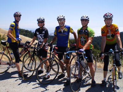
 Now we go back along the Mt. Tam ridgeline with a series of great rollers—fast in the direction we were going in today. When we get to the end of Ridgecrest Don and Dave went right, back to Fairfax—and even though they are cutting miles off the ride they are going to have lots of climbing. The rest of us turn left to go down Fairfax- Bolinas road again—the sun is out but I’m not getting fooled again. I put on vest, arm warmers and gloves. Glad I did and now that road is familiar much nicer time going down it. At the bottom is a large group of Team in Training—toking away.
  Two hours previous the fog was rolling in here, now the only haze was coming from the smoke being passed around this group, Doesn't Team in Training teach cyclists anything??? If your group is going to smoke a joint (tiny red arrow) you HAVE TO BE ON MOUNTAIN BIKES. At the end of Fairfax-Bolinas Road.
Ward, Ron, Chirstine and I now go North on Highway 1 with a half dozen attention getting rollers—and I’m having fun slamming over them. After Olema we take the Ward loop to get off Highway 1, and frighten Christina and Ron by telling them we are going to the lighthouse—which would add @40 hard miles. But we cut into the town of Pt Reyes Station, with lots of cars parked for a hippie faire on the outskirts of town. 
You never know what you'll see on the road in Marin County--police action on the run in to Pt. Reyes Station. (Ward-o-photo)
Great Bovine Bakery had been picked over, but real enjoyable bsing in vacant lot nearby. We take lots of time here (we were hurrying Ron all day so he’s ready when Jack comes back from the Tour de France) and we have the usual nice tailwind as we fly to Nicasio—I’m trying to work hard to be prepped for next week’s finish. Then it’s the fast uphill to the Big Rock Climb—steep but short in this direction, and time to navigate the 16 hairpins coming off it. One car drifts over the center line—when I look at it I hit a pothole and almost wipe out but do a nice save. The downhill finally levels off and it is 21+ mph back to the cars, not bad for after 90+ miles with 8400’ climbing, and two stupid clothing mistakes.
Next week I hope I feel just as good—and that I remember my cycling gloves.
1 comment:
We'll have a lot of good bike riders going for time as Mt. Tam is part of the stage race series. To pharaphase the great Johan Museeuw "I trained well, on Sat. I'll do the maximum, but more I can't do." Hopefully at 6pm we'll still be having fun. Good luck--Jay
Post a Comment